At the Arkansas GIS Office, one of our core responsibilities is to keep the state’s municipal boundaries current and accurate. While boundary changes seldom make headlines, they have real impacts. From how and where cities manage services to how and where elections are conducted, boundaries in the state undergo regular updates to ensure accuracy.
In 2015 the Arkansas General Assembly adopted Act 914, which requires any entity that desires to change a municipal boundary to coordinate with the Arkansas GIS Office for an accurate map of the description of these changes. The Office sends out a letter and map for every change denoting the coordination.
Since that time, the Office has mapped over 1,270 changes to our cities, which were ultimately recorded with the Arkansas Secretary of State. This is the final repository for municipal boundary change records.
Over those years, we’ve tracked hundreds of proposed and completed changes. Our latest numbers from the last two years offer a snapshot of how cities across Arkansas are evolving.
RECENT SNAPSHOT OF CHANGES
In 2023 we recorded 62 total municipal boundary changes affecting nearly 5,880 acres of land. In 2024 we saw 51 completed changes impacting over 6,140 acres, and even more changes were proposed. In 2024, 183 changes were proposed, with 28% completed as of our latest update.
When we break these down by type of change, annexation remains the most common method. In 2024:
- 46 areas were annexed
- 4 areas were detached
- 1 area was incorporated
Compared to 2023, annexation dipped slightly from 57 to 46, while detachments remained steady. Incorporations, though rare, made a return in 2024 after zero were reported the previous year.
HOW DID THE CHANGES HAPPEN?
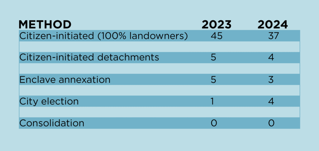
Boundary changes don’t happen in a vacuum. Most of them are citizen-initiated, particularly through 100% landowner petitions. This method accounted for 37 of the 51 changes in 2024. Other methods include detachments, enclave annexations and city-initiated elections. The table below shows how these methods compare year to year.
Though rare, there are cases where city jurisdictions cease to exist. The former city of Jerome in Drew County was the last to surrender its charter in 2021. Regardless, we’re seeing a healthy mix of citizen and city engagement across the board for changing a city boundary.
WHO ADDED THE MOST LAND?
Some cities stood out for their boundary activity. In 2024 the top municipalities by total acreage added were:
- Diamondhead (1,488 acres) was our newest incorporated city.
- Greenland (1,290 acres) was our largest area annexed by election.
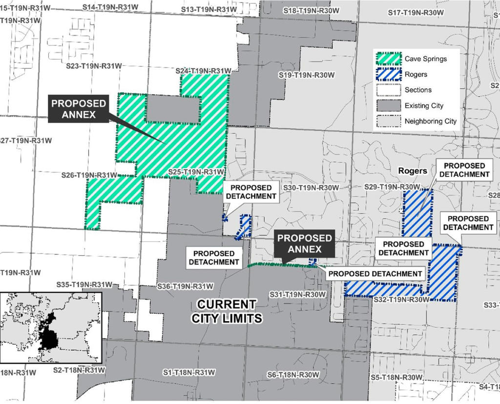
- Cave Springs (573 acres) was part of a significant land swap with Rogers.
- Russellville (476 acres) annexed land by election as a potential casino site.
By comparison, the top contributors in 2023 were:
- Cherry Valley (2,029 acres) annexed land as a potential site for a solar farm.
- Osceola (1,031 acres) annexed land as part of the Hybar Steel manufacturing site.
- Greenwood (438 acres) annexed land as part of the city’s municipal water supply.
- Berryville (288 acres) annexed land as part of the city’s newly developed business park.
Large-scale changes such as Berryville’s annexation activity often reflect local growth patterns, community needs or long-range planning efforts. The expansion at Berryville’s business park more than doubled the size of Mid-States Specialty Eggs’ original space. The company processes and distributes more than 1.2 million specialty eggs a day that are shipped to places within Arkansas and to Nebraska, South Dakota, Texas, Illinois and California.
Berryville annexed 288 acres at its business park in 2023 to accommodate the expansion of Mid-States Specialty Eggs.
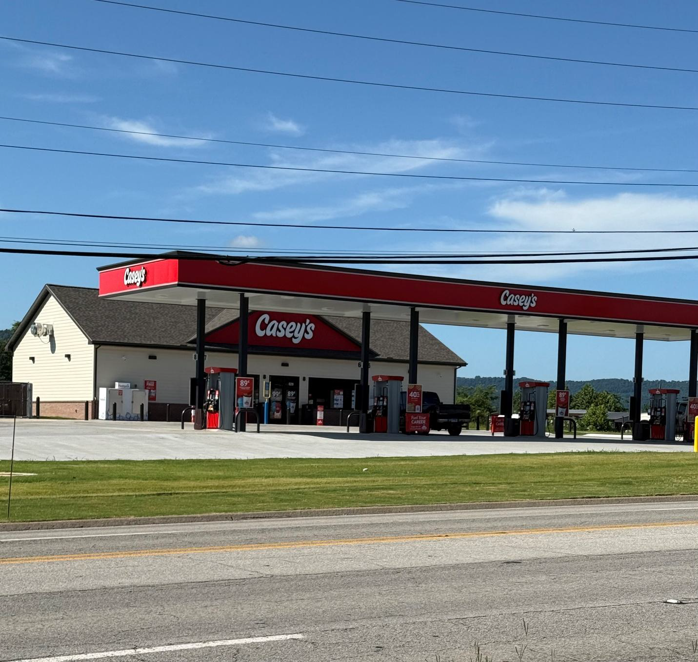
Sometimes the changes are small but essential. In 2024, when Marshall Mayor Kevin Elliot learned that a Casey’s convenience store was in the works on a stretch of real estate along Highway 65 that was not in the city, he worked with the relevant property owners to petition to join the city. The store opened this year and is now contributing to the sales tax base for the city.
THE MOST UNIQUE BOUNDARY CHANGE
The most unique municipal boundary change in 2024 was brought forward by city leaders from Cave Springs and Rogers, who completed a very large land swap (see map below). This swap entailed roughly 573 acres being added to Cave Springs and roughly 256 acres being added to Rogers. The action is intended to streamline the delivery of municipal services to residents of both cities in the areas affected.
WHY DO CHANGES FAIL?
With a quick look back through the contemporary boundary-change records, we found 177 annexations that failed. The reasons vary. In the city of Goshen, an annexation by election failed to receive enough votes. However, annexations by election are by far the least used method of changing a city boundary.
A few annexations were withdrawn by the petitioner, a few would have created enclaves, and in other instances the city council rejected the change. There were very few instances where the change was initially rejected by a county judge, and those were almost always attributed to the annexation leaving a county road out as county jurisdiction. County judges generally prefer those roads be taken in to be maintained by the city. Those instances are usually quickly resolved by correcting the legal description of the annexation to include the road and its adjoining right-of-way.
However, there is one fatal flaw in the system of processes which causes municipal boundary changes to fail: too many cooks in the kitchen.
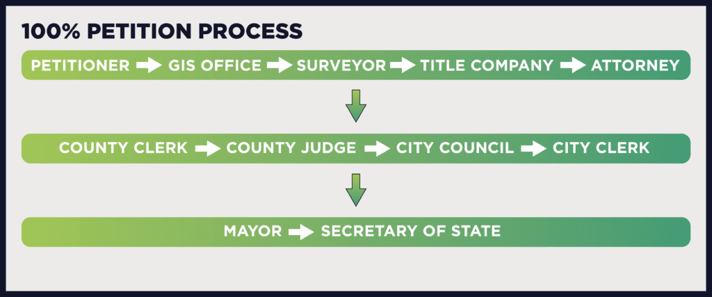
The most common annexation method is the 100% petition process. That method has a long roster of actors: petitioners, the Arkansas GIS Office, attorneys, abstract/title company, surveyors, County Clerk, County Judge, Mayor, City Clerk, and City Council.
At the close of each step, there’s a handoff and the need to move the documentation and process on to the next cook in the kitchen. These are processes that require continual coordination and follow-up. At the end of the story some of these 177 are not failures, instead they are just stalled somewhere along the process.
LOOKING AHEAD
Many of the 177 attempted annexations were not necessarily failures. Instead, they are just stalled somewhere along the process. The most common annexation method is the 100% petition process, which has a long roster of actors: the petitioners, the Arkansas GIS Office, attorneys, abstract/title companies, surveyors, county clerk, county judge, mayor, city clerk and city council. It is a long, complicated process that requires continuous coordination and follow-up. It can bring to mind the old adage: too many cooks in the kitchen.
To help address this issue, the ArkansasGIS Office built an online map to help cities, property owners and other stakeholders find where a boundary change might be stalled. After a proposed annexation leaves the GIS Office, it’s added to our CheckMyCity map app, where its progress is color coded:
- Blue: Sent out by GIS (0–6 months)
- Yellow: Pending more than 6 months
- Red: Over a year has passed and still not filed with the Secretary of State
A red polygon, for example, flags an annexation that’s been in limbo too long, prompting city officials to identify where the process may have stalled. The CheckMyCity tool promotes accountability and transparency while helping ensure that boundary updates make it across the finish line.
We’re proud of the work that goes into maintaining accurate, real-time boundary data. It’s a collaborative effort among local governments, petitioning citizens and the GIS professionals who keep it all tied together. Whether you’re a planner, policymaker or simply a curious citizen, these updates help ensure the map matches the ground.
You can always explore current municipal boundaries and proposed changes through our GIS portal and stay connected with how Arkansas continues to grow and change, acre by acre.